01 / Your Property
Locate your land using GPS coordinates and satellite imagery. Draw your property boundary, examine the available space and create a starting point for the project.
A LAND-PLANNING TOOL BY LEGACY FOOD FOREST
Your land deserves a plan that brings everything together.
You've bought the property. You have ideas for the house, the orchard, the roads, the garden, and the life you want to build.
But where does everything go?
Groundwork helps you see the whole property before making expensive decisions on the ground.
Start with real satellite imagery of your land. Define your boundaries, explore where buildings belong, lay out access and utilities, and plan the productive landscape around it all.
See the possibilities. Understand the space. Make better decisions before the work begins.
Groundwork subscriptions opening soon.
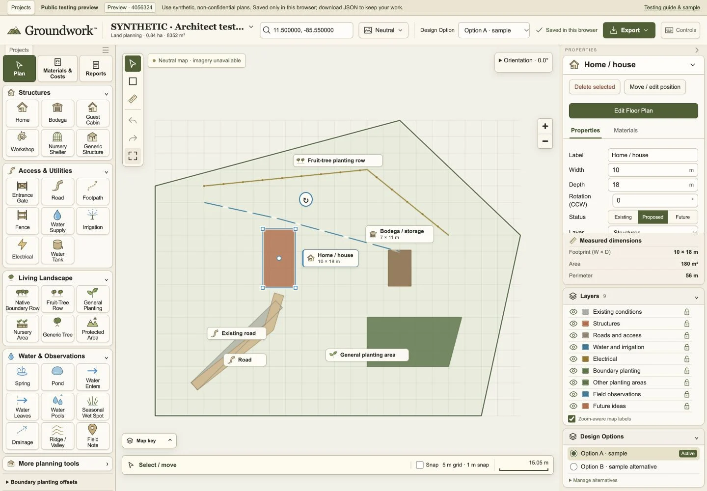
They all affect each other.
Where you build the house changes how you access the property.
Where you put the road affects drainage, utilities, planting space, and future construction.
Where you plant your first fruit trees matters when the equipment arrives.
And every time you change one decision, the rest of the property may need to change with it.
Groundwork gives you one place to work through those decisions visually.
Instead of keeping separate sketches, satellite screenshots, measurements and ideas in your head, you can bring them into a single land plan.
The goal is simple: plan the whole property before committing to the parts.
Your property is the starting point.
Every piece of land is different.
Groundwork starts with your actual geographic location, using satellite imagery to help you understand the shape of the property and how its different areas relate.
Define the property boundary. Explore the available space. Organize the land around what already exists and what you want to build.
Use a metric grid, measured drawing tools and editable layouts to develop your plan at a meaningful scale.
Whether you're working with a compact homestead or several acres of tropical land, you can begin seeing how your ideas fit together.
A connected workspace for the decisions that come first.
Locate your land using GPS coordinates and satellite imagery. Draw your property boundary, examine the available space and create a starting point for the project.
Lay out entrances, roads, walking paths, fencing, water lines and electrical routes. Explore how essential infrastructure can reach the places that need it.
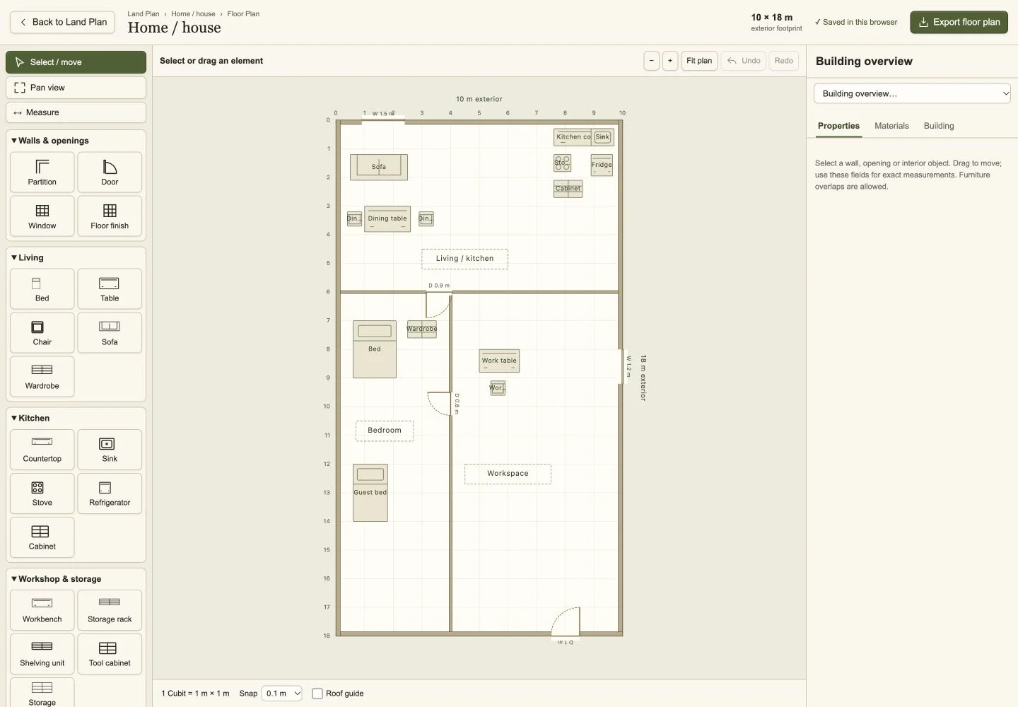
Position your house, cabins, storage buildings and other structures on the property. Explore dimensions, layout alternatives and how structures relate to their surroundings.
Open the 2D Building Detail editor to sketch interior partitions, openings and basic room arrangements.
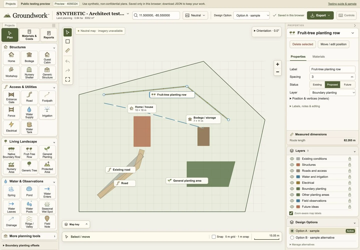
Reserve space for fruit trees, orchards and productive growing areas. Explore tree spacing, canopy coverage, planting rows and how your food system fits around the built environment.
Your first idea doesn't have to be your final decision.
Organize different parts of the plan into layers, show or hide details, and develop alternative layouts without losing your earlier work.
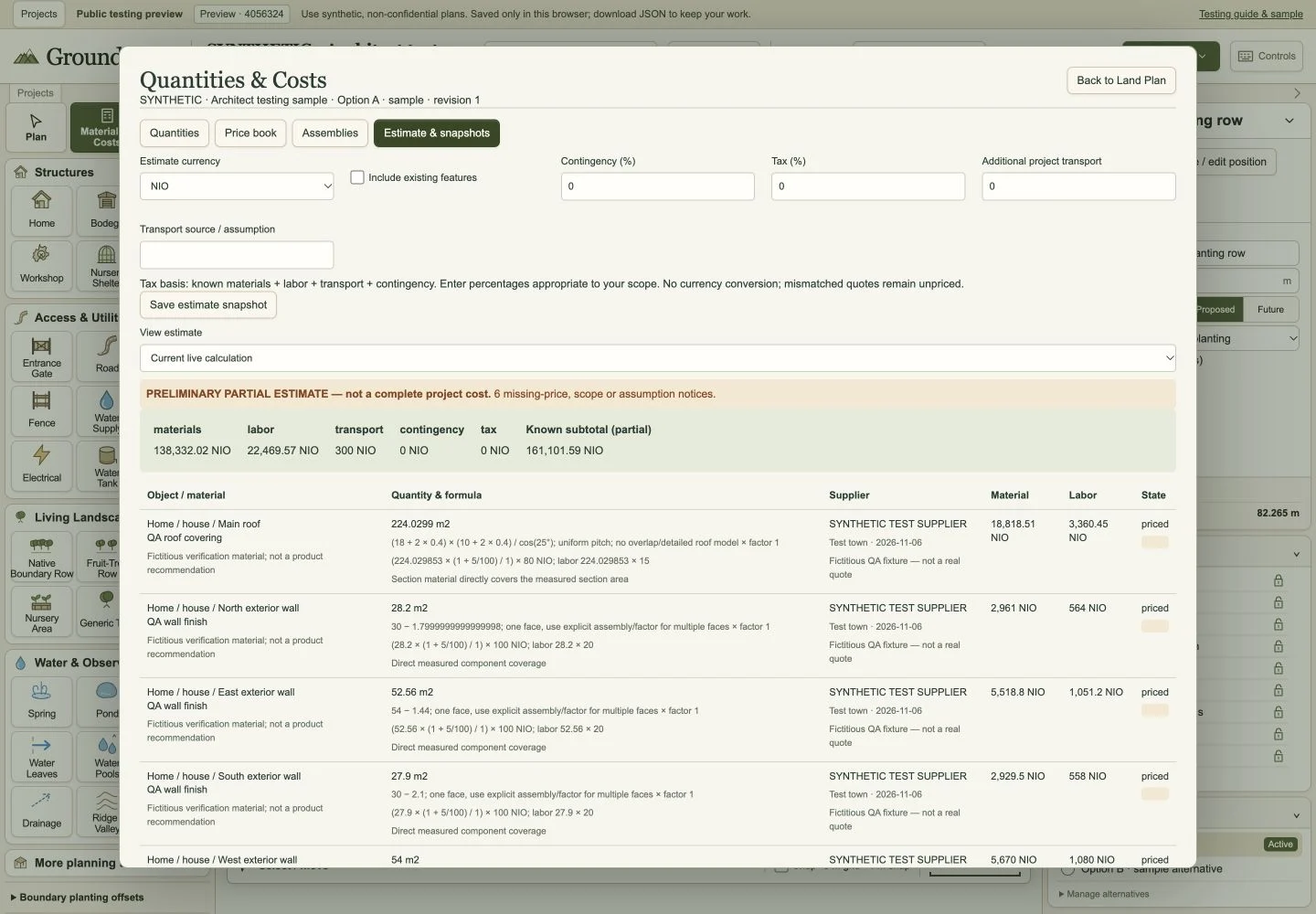
Turn parts of your design into preliminary material quantities and cost estimates.
Use editable supplier prices to explore how different choices could affect your budget.
These are early planning estimates, not contractor quotations.
Export your project as a portable plan you can keep, review and share.
Groundwork also prepares an AI-rendering export package to help you develop visual concepts using compatible external AI tools.
That's where planning pays off.
Imagine realizing that the house would work better ten meters farther uphill.
Or discovering that a proposed access road passes through the area you wanted for your orchard.
Perhaps you want to compare two cabin locations, change the entrance arrangement, or leave more space around the future nursery.
In Groundwork, you can explore those choices in a visual plan before the work becomes permanent.
Move a proposed building. Revise a path. Change a planting arrangement. Compare a different layout.
It's easier to change a drawing than to move a finished building or replant an established orchard.
Begin with its GPS location and satellite view.
Outline the parcel and get oriented to the land.
Place buildings, entrances, access routes, water infrastructure and productive growing areas.
Adjust locations, review dimensions, compare alternatives and prepare estimates.
Export your work to help guide conversations with your family, designer, builders and local crew.
A useful plan should help everyone understand what you're trying to create.
Whether you're preparing to move abroad, developing a family homestead, planning a food forest, or helping someone else organize a property, Groundwork provides a shared visual starting point.
You don't have to be an architect to begin exploring the layout of your land.
And if you're a land designer or consultant, you can use the same planning environment to develop and communicate concepts with clients.
Groundwork is built for the early decisions that shape everything that follows.
From Legacy Food Forest.
At Legacy Food Forest, we approach land establishment with one guiding principle:
Establish the land while you establish the home.
A productive property needs more than a beautiful house or a collection of fruit trees.
It needs access that works, water where it's needed, space for the people who maintain it, and a planting system that can grow alongside the built environment.
Groundwork brings that way of thinking into a visual planning tool.
Plan the infrastructure with the living landscape in mind. Give your food forest a place in the plan from the beginning.
The result is a clearer direction for the land you're building, the people working on it, and the life you want it to support.
Groundwork is a product of Legacy Food Forest.
Discover Legacy Food ForestGroundwork is coming.
We're preparing Groundwork for landowners, homesteaders and property designers who want a clearer way to plan what comes next.
Explore your property's possibilities, organize the major decisions and develop a plan you can refine as your project grows.
Groundwork subscriptions will open when the customer application is ready.
Subscription pricing and access details will be published before purchases open.
No. Groundwork is being designed for landowners who want to understand and organize their own property, while offering useful tools for professional designers.
Yes. You can explore a location and develop preliminary layout ideas before you own the land. Property boundaries and access rights should be verified independently.
Yes. The planner uses geographic coordinates and satellite basemaps to help you visualize your property. Satellite imagery may be older or offset from surveyed positions.
Yes. Groundwork includes planning tools for trees, planting areas and spacing alongside buildings, roads and utilities.
Groundwork can develop preliminary quantities and estimates using editable material prices. It does not replace contractor quotations or professional design assessments.
Groundwork can export design information for use with external AI rendering tools. Built-in photorealistic rendering is not currently offered.
No. Groundwork is a conceptual planning tool. Legal boundaries, terrain conditions, construction requirements and regulated designs still require appropriate field verification and qualified professionals.
Subscription access is being prepared. Pricing, payment and account activation will be announced when the customer version is ready.